My Journey to Teaching

Category: EdTech Inquiry

Cool things to do on Google Earth!!!


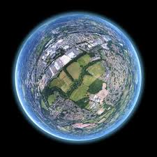
Here a just a few of the fun (and educational) things you and your students can play around with on Google Earth:


Find Your House

Search for your address. In the search results, double click your address and Google Earth will fly you to your neighborhood. Drag the Pegman to get to Street View and get an up-close look at your home.


Create Tours

Record customized tours that you can share with others (great for lessons or assignments!).

  1. Click “Add-Tour” or, in the bar above the globe, click Record.
  2. To start recording, go to the lower left corner in the media player and click Record/Stop.
  3. To record audio, click Microphone.
  4. Travel to each place you want to visit, or go to the left-hand panel under “Places” and click a place-mark to fly to that location.
  5. When you finish recording, click Record/Stop.
  6. In the lower right corner, a media player will appear and your tour will start playing.
  7. To save the tour, click Save in the media player
  8. In the box that opens, enter a title in the “Name” field.
  9. To add more info about the tour, use the “Description” and View tabs.
  10. Click OK.

To play a tour, go to the left-hand panel under “Places – My Places.” Click the tour you want to watch. You can also narrate your tour by hitting the Microphone button instead of the Record button.


View the Past

View older imagery of locations to see how places have changed over time. To do this, click “Time” in the toolbar. When it appears, move the slider to see images from the past.


View Layers

The Layers panel allows users to turn different data layers on and off in the 3D Viewer display. Layers display, for example, a variety of neato geographic content. To view a layer, check the layer (or layer folder) in the Layers panel.
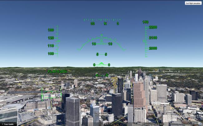
 

Flight Simulator

One of the gems on Google Earth is the flight simulator. The flight simulator mode does exactly what the name implies – it allows you to take on the role and control of a pilot as you fly across the globe.
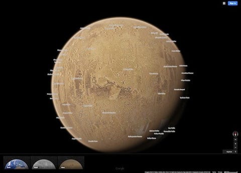
 

“I’m Feeling Lucky”

Google Earth has the “I’m Feeling Lucky” button (similar to the one you see on Google Search). Just click the button and you’re transported to a random location around the globe. For a particular place, Google Earth now shows an information card which leads to a dedicated page described more information.


Voyager

In 2017, Google teamed up with NASA, the Jane Goodall Institute, the BBC, and Sesame Workshop to create Voyager. This feature includes select places to take interactive, guided virtual tours in the form of map-based stories (click the ship’s wheel icon to try it out), and provides the user with lots to do, learn, and explore. For example, one tour takes you Tanzania’s Gombe Natural Park where you can view the human-like behavior of chimpanzees. Voyager takes the user to their desired destination and immerses them into a global adventure where there’s a lot to do, learn, and explore.

Two of the first Voyager stories to be published were Earth View and Miniatur Wunderland.

Earth View allows you to explore a collection of the most striking and enigmatic landscapes gathered by high-quality satellite that are available in Google Earth. Your favourite Earth View images can be accessed via markers on the globe.

The Miniatur Wunderland exhibition, located in Hamburg, Germany, is the world’s largest model railway. Google built a mini version of their Street View car to capture footage within the exhibition. Users can see the various worlds found in the Miniatur Wunderland on Google Street View.

Other fun Voyager-based activities to use with your students:

  • Explore classrooms from around the world and compare and contrast your own classroom with others.
  • Experience interactive stories from around the world for an after lunch cool-down activity.
  • Fly through landmarks from around the world.

Also see: https://www.teachstarter.com/us/blog/20-google-earth-activities-for-students-bringing-the-wow-factor-to-your-lessons-3/ for more cool lesson ideas that incorporate Google Earth.


Google Sky, Mars, and Moon

Image result for google earth

Google Earth doesn’t only mean a user can trot around the Blue planet. The amazing application also lets us explore the sky, Mars, and the Moon! All you have to do is click on the icon that looks like Saturn (used here probably because it’s the most recognizable planet) on the top of the Google Earth page. See below for more information:

Image result for google sky

Google Sky shows the stars, planets, and galaxies from the perspective of Earth, and allows the user travel through the cosmos at their own pace. Sky was created by stitching together imagery from a variety of scientific third parties, such as the Space Telescope Science Institute (STScI). It can, for example, be used to view and navigate through hundreds of millions of individual stars and galaxies, and explore the planets. Imagery that is very high-resolution, paired with very cool and informative overlays, create a virtual experience that is a super engaging way to learn about space. Data on Sky is constructed in layers, such as “constellations” (shows the labels and patterns of constellation), “backyard astronomy” (shows a variety of place-marks and information on stars, galaxies, and nebulae), “our solar system” (shows images and info about the Sun, Moon, and planets), and “featured observatories” (shows images from a selection of the world’s most famous observatories, including the Hubble Space Telescope). Sky also gives information on where certain stars or galaxies can be found. A great way to learn about Google Sky is by click on the “Touring Sky” box!

Image result for google mars

Google Mars takes users from the Blue planet straight to the Red planet! As with Google Earth, users can turn information layers on and off. This allows you to, for example, search for specific landmarks and leave place-marks. Users can also see: 3D images of terrain, images of the surface (including infra-red), and great quality orbital images, high-quality photos, and 360-degree panoramas taken by various Mars landers. To get a good overview of Google Mars and to learn more about what you are seeing, take a guided tour or check out “A Traveler’s Guide to Mars.” You can also click on “Live from Mars” to find, among other information, recent pictures and orbiting paths of spacecraft. In the best cases, users can see images that were taken mere hours before. Once you’re tired of seeing red, you can also visit the International Space Station, or other planets such as Saturn, Pluto, Venus, and Mercury.

Image result for google moon

Google Moon allows users to explore the most famous (and most visited) moon in the solar system. Like Google Earth, Moon has many layers for users to play around. One of the most noteworthy is the layer that allows you to learn more about Apollo missions 11-17 (includes history of missions, photos taken from EVA suits by astronauts from a given mission, and even tours of lunar sites narrated by Apollo astronauts!). Also included on the site are 3D models of rovers and landers, 360-degree photo panoramas, and footage of the Apollo missions. Another cool feature that might be especially relevant to a school setting is the “ruler”, which allows students to measure distances, diameters of craters, and follow paths taken by Lunar buggies.

All in all, Google Sky, Mars, and Moon offer great ways to provide students with engaging lessons on all things out of this world!


Google Earth vs Google Maps – What’s the Difference?

Image result for google earth

Before starting out my Tech inquiry on mapping I knew, of course, about Google Maps and was familiar to a small extent with Google Earth. However, I couldn’t really tell you what the difference was. As far as I could tell the applications were, to a large extent, redundant. But after digging a little deeper, I discovered that the two programs were both unique and practical in their own ways. So what’s the difference?

Google Maps is for routing and getting to places, and contains all the navigation, lightweight mapping power and points of interest. However, it possesses only low res, 2D satellite imagery so isn’t a great way to get a feel for where you’re heading. The street view feature is fine for close up images, but not if you want to zoom out a bit more. In essence, Maps favours utility over experience. Google Maps is most useful when a person is looking places to go and ways get there, with turn-for-turn navigation for biking, driving, walking, and bus-ing. The strong points of Maps are the maps themselves and points of interest (parks, schools, government buildings, etc). While Maps will cover the majority of what people need from a mapping app, if one is looking for the highest-detailed information, then Google Earth is where they will find it.

Google Earth is for exploring. It has complete high res 3D satellite data and only a little bit of information on places (and no point-to-point navigation). The point of Google Earth is visiting different places virtually in 3D – there aren’t many other features to distract the user. While not offering the rich data experience that Maps provides, if you want to really look around and see what things are like, Earth is the app for that. In essence, it favours experience over utility. The user can get guided fly-by tours of buildings and cities, or they can simply explore by zooming, scrolling, or panning. It can give you a great feel for the size of buildings and the topography of a given location. The combination of Street View with sophisticated satellite imaging  makes for a great way to look around almost anywhere in the world, whether zoomed in or out. Earth also has the Voyager feature. This feature is a showcase of guided tours, intended to curate or guide your experience with the platform. The tours are in the form of map-based stories. One part of Voyager is known as Earth View, which combines high-quality landscape images of random places. Lastly, Google Earth has the “I’m Feeling Lucky” button. If you click on the button, you are taken to any random location across the globe. For any given place, Google Earth shows an information card which leads to a page dedicated to providing more information.

So, while Google Maps and Google Earth are similar in certain respects, they both have unique features and capabilities which provide teachers with interesting possibilities for introducing maps and technology into the classroom.